
The fires here are looking pretty good at the moment, as of yesterday afternoon anyhow. It was quite windy, but apparently it was driving the fire up into the alpine, rather than down into more timber. It also switched back onto itself a bit, which is a really great turn. Cats are working on a fire guard right in front of it, and that seems to be working as well. There wasn't the amazingly huge column of smoke yesterday afternoon that we have had previously, so that is encouraging.
Rumour has it that, if operations continue as they are (without any more challenges from Mother Nature), we should be able to feel fairly safe by tonight. The smoke has cleared quite a bit and that we are now able to see the mountains through the haze. The weather has turned relatively cool, and it looks though it may rain. Hopefully not thunder storms!
A fire camp has been set up again at the Anahim Lake Airport, and a Type One Crew from Ontario has taken over. The major concern is simply lack of resources. There are so many fires in BC that crews and equipment is getting spread pretty darn thin.
There have been several pieces of big equipment burned, as well as at least one truck, a four-wheeler, and some trailers, but as far as I know, no major structure has been destroyed. And, most importantly, no-one has been seriously hurt.
This is of course, not written in stone by any means, just the basics of what I have been told. And, despite what I hear the media is saying, we were never evacuated, just put on a two hour alert.
Thursday, July 06, 2006


Wednesday, July 05, 2006
Chilcotin fire evacuations north of Anahim Lake
Fire evacuations ordered in the Cariboo-Chilcotin
July 5, 2006
About 2,000 people living in remote communities in B.C.'s Cariboo-Chilcotin region have been forced from their homes by the threat of two massive wildfires.
Full story
BC Forest Service: Cariboo fire update
For current updates:
 Active Cariboo fires
------------------------------
A friend sent me this from the BC Forest Service:
INFORMATION BULLETIN
For Immediate Release
July 4th, 2006
Ministry of Forests and Range
BC Forest Service
Cariboo Fire Centre
SMOKE FROM WILDFIRES AFFECTING THE CARIBOO
WILLIAMS LAKE – Smoke from the various wildfires in the Cariboo is drifting into surrounding communities. Smoke and ash have been reported in most areas of the Cariboo. The recent hot and dry weather has made fire behaviour extremely active.
The smoke is mostly a result of 3 fires of note: the fire near Tezla Lake, about 48 kilometres northwest of Anahim Lake, which has grown to over 7000 hectares; the fire near Narcosli Lake, which is now burning at over 3000 hectares; and the fire northeast of Wutlus Lake, about 60 kilometres west of Quesnel, which has reached 3500 hectares.
Due to active fire behaviour on the Wutlus Lake fire, the Nazko Highway is closed in both directions from 5.4 km east of Nazko to 33.4 km west of Quesnel. For more information and for up to date road conditions please see www.pep.bc.ca or www.drivebc.ca.
Crews are also battling a number of smaller fires within the Cariboo Fire Centre, mostly located in the West Chilcotin. Fire crews are working as hard as possible to contain the fires with the resources available to them. There are over 200 firefighters working throughout the area, as well as contracted support staff. They are assisted by heavy equipment, airtankers and helicopters.
Fire information and updates can be found on the protection website at www.for.gov.bc.ca/protect or call toll-free 1-888-3FOREST. If you see a wildfire, please report it to 1-800-663-5555 or *5555 on most cellular networks.
Contact:
Kim Steinbart
Fire Information Officer
250-989-2655
Active Cariboo fires ------------------------------
A friend sent me this from the BC Forest Service:
INFORMATION BULLETIN
For Immediate Release
July 4th, 2006
Ministry of Forests and Range
BC Forest Service
Cariboo Fire Centre
SMOKE FROM WILDFIRES AFFECTING THE CARIBOO
WILLIAMS LAKE – Smoke from the various wildfires in the Cariboo is drifting into surrounding communities. Smoke and ash have been reported in most areas of the Cariboo. The recent hot and dry weather has made fire behaviour extremely active.
The smoke is mostly a result of 3 fires of note: the fire near Tezla Lake, about 48 kilometres northwest of Anahim Lake, which has grown to over 7000 hectares; the fire near Narcosli Lake, which is now burning at over 3000 hectares; and the fire northeast of Wutlus Lake, about 60 kilometres west of Quesnel, which has reached 3500 hectares.
Due to active fire behaviour on the Wutlus Lake fire, the Nazko Highway is closed in both directions from 5.4 km east of Nazko to 33.4 km west of Quesnel. For more information and for up to date road conditions please see www.pep.bc.ca or www.drivebc.ca.
Crews are also battling a number of smaller fires within the Cariboo Fire Centre, mostly located in the West Chilcotin. Fire crews are working as hard as possible to contain the fires with the resources available to them. There are over 200 firefighters working throughout the area, as well as contracted support staff. They are assisted by heavy equipment, airtankers and helicopters.
Fire information and updates can be found on the protection website at www.for.gov.bc.ca/protect or call toll-free 1-888-3FOREST. If you see a wildfire, please report it to 1-800-663-5555 or *5555 on most cellular networks.
Contact:
Kim Steinbart
Fire Information Officer
250-989-2655
Anahim Lake area fires, 2006
Once again the Anahim Lake area is threatened by fire. I have a number of friends and clients in that area and am attempting to keep in touch with the situation. There isn't a lot of information available in the media. This is how it was last time there was a large fire in that area - in 2004. At that time I carried reports and pictures from people I knew who live in the area. It might be time to do that again. If you have reliable information on this fire, contact me via the Inside BC web site.
Meanwhile, here's what I've come up with at this point:
Click on the number to get more information and on the button to see the location
Meanwhile, here's what I've come up with at this point:
July 4: The forest service is also battling a wildfire in the Anahim Lake area which has forced the evacuation of one resident. Five aircraft and 118 firefighters have been dispatched to combat that blaze. - Global National (Canadian Press)
July 4: The largest fire is located 48 kilometers northwest of Anahim Lake by Tezla Lake, and was reported at about 7 p.m. on Sunday. "The largest fire is currently at 150 hectares, and it's considered out of control right now," spokesperson Kim Steinbart said. There are buildings in the area and so far one resident has been asked to keep away from the area because of the air tankers and other firefighting activities. She said that nearly 100 firefighters are on the scene with eight pieces of heavy equipment.- Williams Lake Tribune
This information is provided by the BC Ministry of Forests:
| Fire No. | Geographic | Discovery Date | Hectares |
|---|---|---|---|
C50150  | 5.5 km N of Tezla Lk | Jul 2, 2006 | 50.00 |
| C50148 | 2.4 km N of Tezla Lake | Jul 2, 2006 | 9,000.00 |
Click on the number to get more information and on the button to see the location
Monday, June 26, 2006
Mining Minister Responds to Tyee Story on Land Disputes
. . . and their reporter replies to his letter.
Read the story
Thursday, June 15, 2006
BC land-owners vulnerable to prospecting miners
It appears that mining rights to much of BC's land has been bought up - thanks, at least in part, to the provincial government's online staking system. According to Kendyl Salcito in The Tyee, this system:
allows anyone with internet access and $25 to acquire a miner's license and then, at $0.17 an acre, buy mineral rights to land. It doesn't matter whether that land belongs to a neighbour, the Crown, or the "miner" himself. Once you own the mineral rights, you are free to "explore" your claims, wander the property, "poke at a few rocks," in the words of MP Tom Christensen. And once you decide to start drilling and digging, even the landowner's dwelling and buildings are at risk.
Saturday, June 10, 2006
BC Grasslands at risk
Will one of Canada's most endangered ecosystems receive National Park status?
by Heather English
The Dominion

The South Okanagan Valley contains more ecological diversity than any other in British Columbia.
photo: Dick Canning
photo: Dick Canning
When driving along Highway 3 in southern British Columbia, you’ll find yourself looking out over the South Okanagan Valley; a landscape made up of a mosaic of green, yellow and brown shades, each a different ecosystem. From the bunchgrass ecosystem in the lower elevations to the alpine tundra in the mountaintops, this region contains more ecological diversity than any other in British Columbia. The valley bottoms support more than just ecological diversity; they also support a booming tourist economy, cattle ranching, agriculture and vineyards. The opposing interest groups in the region have made the proposal for a national park reserve controversial and the region’s future uncertain.
Read on
For more images and information on the BC Grasslands, read Chris Harris' Grasslands photo journal.
Sunday, June 04, 2006
New Photo Journal from Chris Czajkowski
 Put a camera in the right hands and a new world opens up for a lot of people. Chris Czajkowski has had a digital camera for a few short months and already she has generated some striking images of her world in the Chilcotin wilderness of BC. Many wilderness lovers know her through her books and slideshows. They will be delighted at this more expansive view of her world, presented though her online Photo Journal. For those who don't know Chris, this is a very good introduction to her and the world she knows and loves.
As her web designer for over five years, I've edited and placed many pictures on her web site but these carry a heightened immediacy. With Chris living off the grid and far from photo-processing labs, this is a classic example of the value of digital technology: high-tech in a low-tech setting.

Tuesday, May 23, 2006
Children form 100-foot mountain caribou
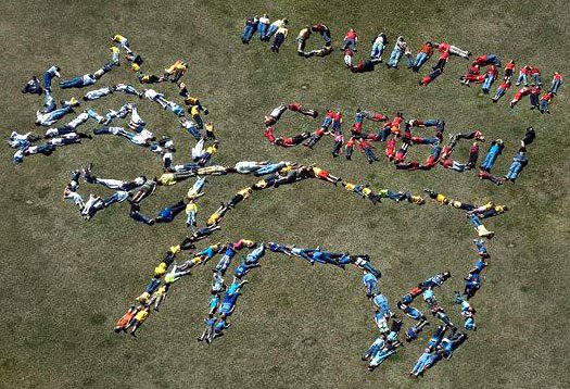 Nearly 200 students, teachers and parents from Lindsay Park Elementary School in Kimberley, B.C., bent and stretched their bodies to from a 100-foot mountain caribou to help raise awareness for this critically endangered species. Fewer than 1600 mountain caribou remain in the world, almost all of which live in B.C.. The Purcell herd near Kimberley has dwindled to fewer than 20 animals in recent years.
Visit www.mountaincaribou.org
Wednesday, May 17, 2006
A timely review of BC's endangered Mountain Caribou:
Many culprits active in caribou decline - May 15, 2006
Biologists who have been studying mountain caribou in B.C. for 20 years expect several of the small groups will disappear soon. The biggest herd consists of about 525 caribou, and it is considered relatively stable. But the rest are pretty much on their way out - unless a government caribou-recovery strategy that is expected to be finalized this fall can save them.
Subscribe to:
Posts (Atom)